The City of Lone Tree, in partnership with Douglas County and other local agencies, is developing a long-term vision to address safety and mobility needs for Lincoln Avenue from Park Meadows Drive to Oswego Street, including the I-25 interchange. To ultimately construct improvements for this corridor, the local agencies are conducting a robust public outreach process to gather community and stakeholder input to understand existing conditions, future development and multimodal transportation needs in the corridor. The project team is performing a detailed alternatives screening analysis that includes:
Collecting extensive traffic data
Modeling existing traffic conditions
Modeling future operations of project alternatives
The recommended alternative will then undergo the National Environmental Policy Act (NEPA) process and preliminary design will begin. These tasks are collectively referred to as the “project.”
The Advancing Lincoln Avenue Project is a priority transportation initiative for Douglas County and the City of Lone Tree. Lincoln Avenue is a vital regional arterial in Douglas County. This stretch of Lincoln Avenue is the gateway to Lone Tree’s City Center and the heart of the City’s most significant existing and planned developments, providing access to:
Providing safe and reliable travel options for all who use the Lincoln Avenue corridor is vital to the community’s success.
Click Map to Enlarge
Advancing Lincoln Avenue
The Advancing Lincoln Avenue Project is a priority transportation initiative for Douglas County and the City of Lone Tree. Lincoln Avenue is a vital regional arterial in Douglas County. This stretch of Lincoln Avenue is the gateway to Lone Tree’s City Center and the heart of the City’s most significant existing and planned developments; health facilities; shopping; residential areas; businesses centers; and regional road, transit, and trail systems. Providing safe and reliable travel options for those that work in, live in, and commute through the area is vital to the community’s success.
The project focuses on Lincoln Avenue between Park Meadows Drive and Oswego Street, including the I-25 and Lincoln Avenue interchange. It will:
Project Basics
The Lincoln Avenue corridor and I-25 interchange have had some short-term improvements, but we are out of easy fixes.
We will develop a long-term solution for the corridor and interchange that can be constructed in the next 5 to 7 years, pending funding.
Safety and congestion issues will worsen as the area and region grow.
Community input will be critical to understanding transportation problems and developing the best solutions.
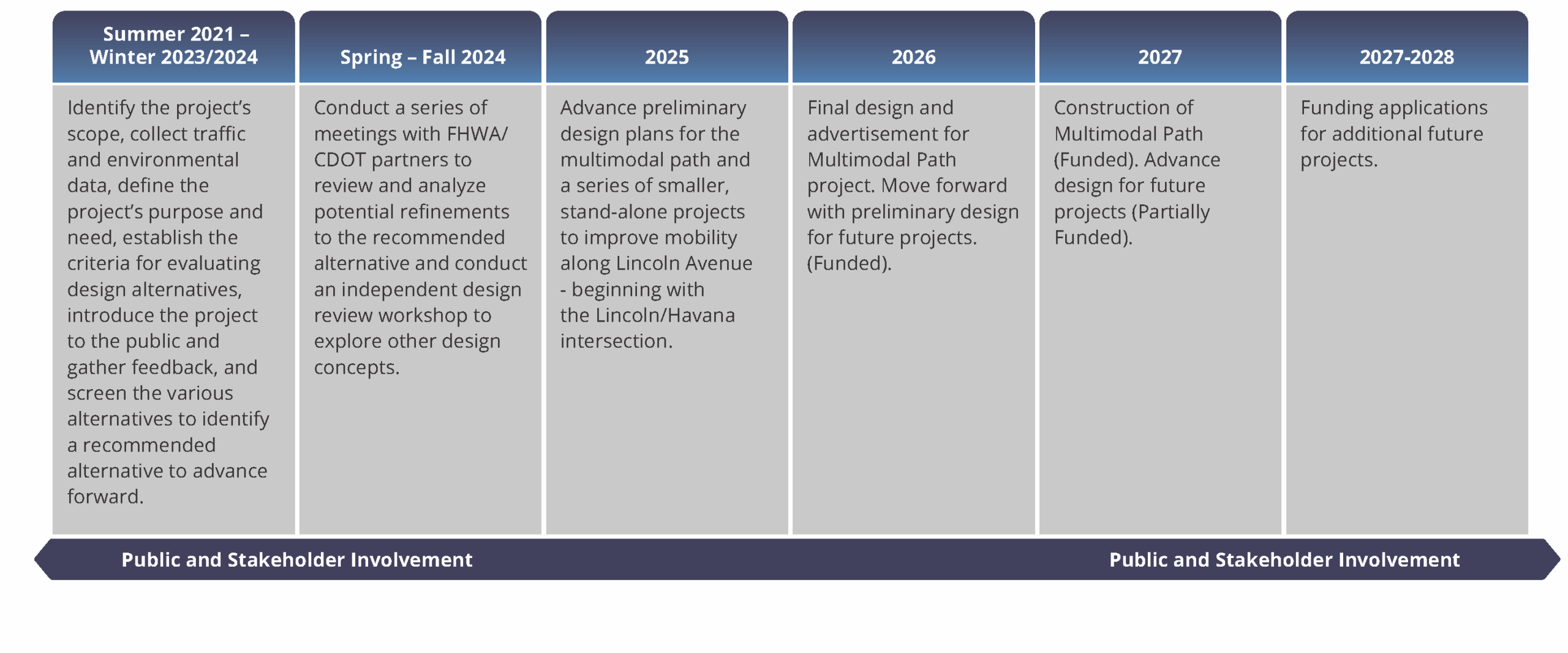
The current effort will advance the project through environmental clearance and preliminary engineering processes.
This initial effort is expected to take 30 months to complete.
Schedule
Connectwith Us
Your input makes a difference and the project team is excited to hear from you! Stay informed and provide comments throughout the project. See email and phone contact information below and look forward to an interactive map coming soon.